
Digital drone tools.Your operation, your way.
Intel.Aero is the digital RPAS tools platform for Australian operators. Rapidly generating reliable compliance and safety documentation automatically from authoritative data sources.
Six weeks → fifteen minutes. Email chain → one click. Spreadsheet → defensible evidence pack.
The Current Digital toolkit. Data Driven Results today.
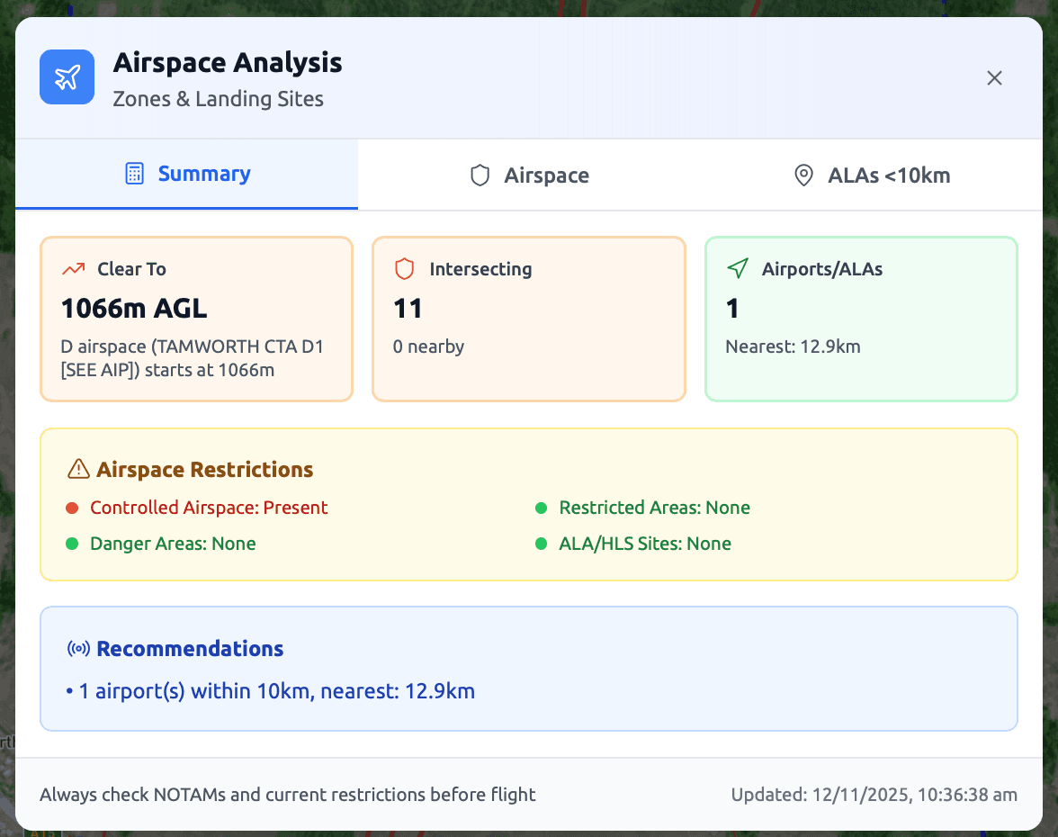
Ground risk, air risk, SAIL — CASA-submission ready.
Powerlines, trees, terrain — recommended safe altitude.
Sky-view & LOS grids to position observers correctly.
Battery, wind & altitude validated against your aircraft.
Next up · Ops Manual · Compliance Checker · Flight Path Designer — same workflow, no upgrade fee.
Digital Tools > Manual Handling
Don't outsource what you can do yourself faster, better and more cost effectively. Get audit-ready documentation in minutes. Accurate, consistent, and CASA-compliant every time.
Stop Paying Thousands ForSORA2.5 Assessments
Full Digital SORA 2.5 risk assessment ground and air. GRC calculates live against 365,000+ ABS datablocks. ARC resolves automatically from airspace data with guided typical/atypical determination. Apply mitigations, see SAIL output, understand your obligtions.


Validate Your MissionBefore You Fly
Three integrated safety checks for your JSA that combat the top causes of drone accidents. Obstacles, crew positioning, and energy constraints validated against 5 national databases in one session. Know your safe altitude, place your crew with confidence, and confirm you have the energy to complete the mission.
5 national datasets. 3 safety checks. One session. Every obstacle, every crew position, every energy constraint validated.
Stop paying for the same answer twice.
Consultants are the right call for first-of-type approvals and BVLOS frontiers. They're the wrong call for the routine missions you'll fly fifty times this year.
- · Discovery workshops from $1,000+, per-project fees on top
- · Their methodology lives on their laptop, not yours
- · 2–6 weeks per assessment — their calendar, your timeline
- · You pay for the same SORA logic every time you re-quote
- ✓ Pilots run the assessment themselves — 15 minutes, in the field
- ✓ Same evidence pack, every assessment, every site, every pilot
- ✓ Fixed subscription — only pay for what you need, no per-quote drag
- ✓ CRP reviews and approves — judgement stays human, evidence is automatic
One platform. Three people who win.
Use both. Use the consultant when you're charting new ground. Use Intel.Aero for everything else.
More missions today makes us more successful tomorrow
The faster and more often we can get you flying safely, the faster we can build the data layer that makes every assessment smarter, and every operation safer. We’re building the tools and removing the bottlenecks to get you flying today, and the data network to make you more successful tomorrow.Your CRP's experience, structured as data from 5 national databases.
Live assessments that update when conditions shift. BVLOS at scale.
The system recommends. Your CRP validates instead of researches.
Your CRP elevates — from paperwork to governing the safety envelope.
This is the operation we're building toward — and every assessment you run gets us all closer. Come build it with us.
Do it yourself. Do it better.
Faster than your consultant. Sharper than your spreadsheet. Signed off before lunch.
Trial: 2 assessments. No card.